
Sunday Run/Hike
Octoberfest Run 2025!!
Next weeks Run #2422
Sunday, July 13, 2025
Time: 2:00
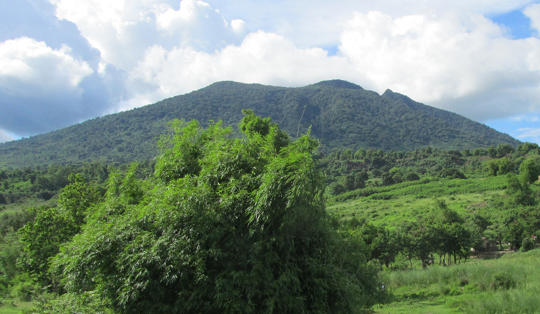
Location: Drive over TB2NW, Right at T-junction, Right at rock crushing plant. After passing over the river on the Baily bridge, pass the wall, turn left at sign "Goshen resort" and left again on 4-lane road. Park on side of road before underpass. I would HIGHLY recommend you follow these directions! Don't get tricky!
Remarks: One trail about 6k. Nothing hard. I wouldn't bring dogs. Do bring a walking stick as it's soft and wet. Should be able to keep dry feet. On Home Premier Hotel
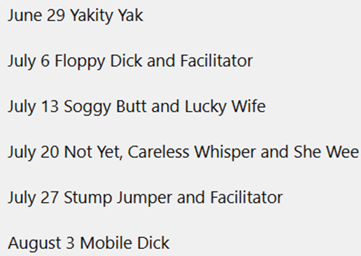
Hare: Soggy Butt and Lucky Wife
Who: All - Adult themed - Children welcome but Parental discretion advised
When: Every Sunday
Price: Men 400 Peso, Women 200 Peso, Kids 100 Peso for ordinary runs. Special runs like the AGPU or Anniverasy may have different run fees.
Upcoming Angeles Hash runs
| Number | Date | Location | Remarks | Hare |
|---|---|---|---|---|
| 2422 | 7/13/2025 | Drive over TB2NW, Right at T-junction, Right at rock crushing plant. After passing over the river on the Baily bridge, pass the wall, turn left at sign "Goshen resort" and left again on 4-lane road. Park on side of road before underpass. I would HIGHLY recommend you follow these directions! Don't get tricky! | One trail about 6k. Nothing hard. I wouldn't bring dogs. Do bring a walking stick as it's soft and wet. Should be able to keep dry feet. On Home Premier Hotel | Soggy Butt and Lucky Wife |
Previous Angeles Hash runs
| Number | Date | Location | Remarks | Hare |
|---|---|---|---|---|
| < 3 4 5 6 7 > | ||||
| 1801. | 2/10/2013 | Bamban. take MacArthur Hiway to Bamban, go over Coat hanger bridge, then turn left, continue on that road for 2K's, then it's a right turn before the Bailey bridge, keep going for about 1-1.5K's. turns will be marked in Calsomine. . | NOTE! on-Home is Brass Knob. If you don't want to go MacArthur, go though Base, and approach the bailey bridge from the other direction..Click on run No. for map.. | Induces Mens. & Girls. |
| 1822 | 7/7/2013 | Bamban.Disused Shell gas Station, right hand side MacArthur Hwy.500m before the bridge. | A to A. On-home Margarita.A hash run for all physical abilities...... | Soggy dickhead |
| 1934. | 8/30/2015 | Bamban.MacArthur highway to Bamban, over the bridge(coathanger) continue on for 300m, then left turn, on for about 1.5km, area to park on you right, will be marked. | Short and Medium trails, there will a split at the 2km mark,Short is Right, Med/Long is Left. On-Home Marble Inn. | Soggy DH. & Mini D’Muncher. |
| 2100. | 11/4/2018 | Bamban.Mango Trees. Over the Bridge to Nowhere, right at the "T" junction, past rock crushing plant, over Bailey bridge, take left turn at end of long wall, follow track for about 1 km to mango trees. Turn-off will be marked. | 5km and 7Km.. the long could be wet feet. Enjoy Hashers.. On-Home Premiere. | Sirena+Stolen Property +Raging Cow. |
| 2078 | 6/3/2018 | Barangay Baliti near Gintung Pak Pak up Arayat way | Take the road to Magalang and turn right at the Jolly Bee going to Arayat. Look for the sign going to Gintung Pak Pak which is by a trike stand. Turn left and drive to just before the bridge. Turn left again there is another sign to Gintung Pak Pak. Continue down that road for about 1 km and park just past Baliti Lake. Beautiful trails. On home Premier Hotel. | Bush Diver |
| 2382 | 10/6/2024 | Barangay Calumpang. Go over TB2NW (Sacobia bridge), take first right - (before top of hill). Continue on the concrete road through village. From where the concrete ends it's aprox. 500 meters to small farm on right. | Trail: 5km, dry feet. The hares claims there is a new small bridge, two waterfalls, fabulous views of the prestine Philippine countryside and a lovely walk/run on trail. We will see... On home is Premiere Hotel. | Bum Steer & Sodermiser |
| 2151 | 10/27/2019 | Barangay Cauyan. On Friendship highway turn east at police station 5. Go to the end of that road 1.7 km and turn left along the dike. After 450 meters turn hard right downhill on steep dirt road. Across dry riverbed and continue on that road 400 meters to the start. See Google earth image for run number | 2 trails 4K and 6K | Guardian angel, skywanker, Joe |
| 2073 | 4/29/2018 | Barangay Cuayan Just after you pass under the clark subic toll rd | Go down Frienship hwy past timog pk turn right at Poinsettia ave Barangay Cuayan police station follow that rd around the dyke too the express way once you pass under it look for marks and parking on the right about 100mtrswe have started from this spot before .The trail is about 7/8 klm not really sure no gps gradual hill if you don,t want to do longer trail and wet feet turn back at the top | lost in subic+Hynd tit |
| 2310 | 5/21/2023 | Barangay Cuayan. Close to the chicken manure field. There are two ways to reach the dike road in Cuayan. One is the usual road through brgy Cuayan from police station 5 at Friendship Hwy/Poinsettia Av. The second is from the cement factory, close to Friendship gate, through brgy Anunas over the new bridge to the dike road. When there, follow dike road past brgy Manuali's brgy hall, under SCTEX and then a right turn to the road to field. Decimal position: 15.0832N, 120.3047E. | 2 trails, short 2.5 km, long 6 km. In the shade as much as possible. Bring an umbrella rain or shine to enjoy your beer under. On home ACEL Clubhouse. | Bonsai & Stump Jumper |
| 2375 | 8/18/2024 | Barangay Manuali, under the SCTEX bridge. From Friendship Highway, go past police station 5 on Poinsettia Avenue, continue through brgy Cuayan. Turn left before the bridge and follow the dike. Pass the brgy Manuali's barangay hall. https://w3w.co/disclose.curries.dine | One easy trail, approx. 7km. Nothing bad. If you have wings you might get back with dry feet. On home Premiere hotel | Two fucking snakes & Not yet |
| 2271 | 8/14/2022 | Barangay Manuali. Close to the chicken manure field. There are two ways to reach the dike road in Cuayan. One is the usual road through brgy Cuayan from police station 5 at Friendship Hwy/Poinsettia Av. The second is from the cement factory, close to Friendship gate, through brgy Anunas over the new bridge to the dike road. When there, follow dike road past brgy Manuali's brgy hall, under SCTEX and then a right turn to the road to field. Decimal position: 15.141881, 120.513702. Click on run # for maps. | Two trails: Medium 6.5 km and Short 3 km. | Stolen Property & Not Yet |
| 2258 | 5/15/2022 | Barangay Manuali. Close to the chicken manure field. There are two ways to reach the dike road in Cuayan. One is the usual road through brgy Cuayan from police station 5 at Friendship Hwy/Poinsettia Av. The second is from the cement factory, close to Friendship gate, through brgy Anunas over the new bridge to the dike road. When there, follow dike road past brgy Manuali's brgy hall, under SCTEX and then a right turn to the road to field. Decimal position: 15.141881, 120.513702. Click on run # for maps. | Only one 5 km trail. Not miles - kilometers. Nice trail with two small hills to go up but only one down. It must be magic! Don't shortcut over the farmers newly planted fields. We want to come back. Also keep all dogs on a leash. Welcome! | Vendor Bender & Suso |
| 2300 | 3/12/2023 | Barangay Manuali. There are two ways to reach the dike road in Cuayan. One is the usual road through brgy Cuayan from police station 5 at Friendship Hwy/Poinsettia Av. The second is from the cement factory, close to Friendship gate, through brgy Anunas over the new bridge to the dike road. When there, follow dike road past brgy Manuali's barangay hall, after 90 degree left turn, continue 100 meter along dike road, turn right down from dike road into field. 15°08'33.7"N 120°31'15.2"E | Trail lengths: Short 4km with a U-turn, Medium 7.8km. On home Premiere. Sponsored by Tanduay Rum. | Two Snakes fucking & Not Yet |
| 2169 | 3/1/2020 | Barangay Mawaque, near Mabiga. GPS Co-ordinates: 15.214186, 120.588291 | From the Mabiga exit on MacArthur Highway, go 400 metres north on the highway and take the second turn on the right down Mawaque Road at the Western Union sign. Go 1.4 kms down Mawaque Road and immediately before the NLEX overpass turn left through the arch marked Bgy Mawaque. Go 800 metres down this road through the barangay. Immediately before you again reach a humpback overpass of NLEX, there are two dirt roads to the left. Take the first of these two paths and drive for 300 metres towards the building with Don Bosco written on the roof. Trails: Short 4 kms. Medium 5 kms. Long 7 kms. All very easy and flat. The trail goes along the Quitingal River and around the lush farms of Mawaque and Dapdap. | Sunshine John and Hellboy (with much help from Purgatory). |
| 1952. | 1/3/2016 | Barrio Pio in between Sugar Mill and Porac, Turn off on the Pio Arch and will be splattered with powder every turn off. | Bring your Wellies. | Single Malt & Sip Sip In |
| 1995. | 10/30/2016 | Barrio Pio,Porac. At the bridge in Porac turn left, and proceed to old road to Subic, bare right, continue on for about 4Km, then it's a right turn that will be marked, continue down to river bank. | Short trail is 4.5Km, long 7.5Km.Easy to moderate trails, wet feet!please bring candy for Aeta kids.Same start as Single malt & Sip Sip in January. On-Home Premiere.The Map I have put on, IS incorrect! disregard it.Now deleted.. | Guardian Angel & Fallen Angel. |
| 1952 | 1/3/1916 | Barrio PIO. The middle between Porac and the Sugar Mill. The turn off on the Pio arch will be splattered with powder. | Bring your Wellies. | Single Malt & Sip Sip In |
| 1702 | 3/20/2011 | Base, opposite McDonalds | ||
| 1775 | 8/12/2012 | Because of the weather, the final decision as to the run location will probably be make on Saturday. Watch this space.OK, these are the details- Go over the bridge to nowhere, as you start going up the hill, turn left at the sign for Paradise ranch,continue on for 700m, park before the gate to the ranch. | On-Home Niagara, the run is A to B.. | 2bottles & Madilyn |
| 1941D | 10/17/2015 | Because of Typhoon Koppu no out of town run today SUNDAY! /Vendor Bender | Town walk from Premiere instead (if you don't mind beeing wet) (The date is wrong - I know - But I couldn't get this information to publish before Soggy Butts run info otherwise) | Who knows? |